National Geographic and MetaCarta Introduce CartaLens Geospatial Digital Asset Management Solution
 San Antonio, Texas, GEOINT 2007 Symposium – October 22, 2007
National Geographic Maps and MetaCarta®, Inc., the leading provider of geographic search and referencing solutions, today announced CartaLens, an innovative geospatial digital asset management solution for georeferencing, managing , retrieving and delivering digital assets. Unlike other digital asset management solutions that only manage structured content, CartaLens is able to search and retrieve location-based information from both structured content and a broad base of digital content such as photos, video, audio and documents, enabling users to fuse digital assets with maps and metadata in a collaborative and interactive viewing environment. CartaLens is being showcased at the GEOINT Symposium in San Antonio, Texas, on October 22-24, 2007, in Booths #341 and #617, and will be showcased in the USGIF Interoperability demonstration.CartaLens makes it possible for organizations and decision makers to efficiently create a focused set of geospatially relevant information from the vast volumes of available information in their libraries, files and across the Web. The solution is ideal for companies, agencies and organizations that have extensive and distributed repositories of mixed content as it creates new opportunities for revenue by repurposing assets in new ways and delivers information when and where it is needed as assets become locationally aware. These target organizations include defense and intelligence agencies, news and media companies, energy firms, public safety agencies, insurance firms and online travel organizations.
“MetaCarta constantly pushes the boundaries of spatial search. CartaLens is a concept and a product that that will push those boundaries well into unexplored and fascinating territory,” said David Sonnen, IDC’s Senior Consultant for Spatial Information Management. “We expect CartaLens to open a whole new set of possibilities for geographic search and discovery.”
“CartaLens is the next generation for search and digital asset management technology,” said Fran Marshall, President of National Geographic Maps. “Like National Geographic, most organizations have large repositories of digital assets. CartaLens has powerful geospatial tools that make it possible to bring users’ digital assets together on the map. Whether they want to find a photo that was taken on a specific date, search their metadata for digital assets that meet certain criteria, or search the map and find all the photos, video and documents within a defined area, users can now collaborate within a Web-based system that brings their digital assets and content together.”
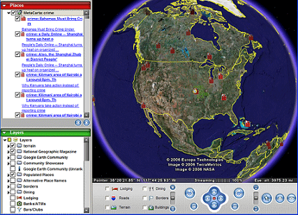
CartaLens enables users to drag and drop assets on to a map which automatically geo-tags the asset for a future geographic search. Its flexible and intuitive interface enables users to identify, locate and access location-aware information by using a map, media thumbnails, or by querying the asset’s metadata. By accessing the CartaLens results dynamically in Google Earth, users can collaborate with their team of subject matter experts in real-time and mix this critical intelligence with other available sources in a 3-D environment.
CartaLens enables users to focus the “Lens” on maps, media, metadata and all-source textual information:
Map-centric Access enables users with constant locational information. All digital assets within the selected search area will appear on the map as icons. Users can click on any point feature on the map to view that asset (photos, videos, imagery, documents, audio or any other digital asset pertaining to that location) along with its associated metadata. Updated maps, imagery, and geographic information are provided through ESRI, and are made available through ESRI’s ArcGIS Server and ArcWeb Services.
Media-centric Access allows users to identify, organize and locate content by clicking on the asset’s thumbnail or detailed data. The map will illustrate where each asset is located providing a quick accurate visual reference that makes it easy to see how assets are related geographically.
Data-centric Access enables users to query metadata to identify, view, categorize and map assets.
“We’re very happy to be working with National Geographic to bring together an innovative and dynamic geospatial digital asset management solution with the world’s most sophisticated geographic retrieval and search solution,” said Ron Matros, President and Chief Executive Officer for MetaCarta. “Our experience in combining geographic search combined with traditional text, or keyword, search has made it possible for our customers to bridge the gap between information and mapping systems—saving countless resource time and effort. CartaLens takes this to the next level by giving our users the ability to tie that information geographically to their digital assets and content.”
About MetaCarta
MetaCarta, Inc., is the leading provider of geographic search and referencing solutions. MetaCarta products make data and unstructured content “location-aware” making that information geographically relevant. Using a map interface, these innovative solutions make it possible for customers to discover, visualize and act on important location-based information. Founded by a team of MIT researchers in 2001, MetaCarta is privately held, with US headquarters in Cambridge, Massachusetts and offices in Vienna, Virginia and Houston, Texas and resellers worldwide. For more information, please visit www.metacarta.com.
About National Geographic Maps
National Geographic Maps was established as a division of the National Geographic Society in 1915 and has been producing maps for National Geographic magazine and other Society media for more than 90 years. National Geographic Maps produces reference maps, wall maps, Trails Illustrated maps, TOPO! and Weekend Explorer 3D outdoor recreation mapping software, globes, state maps, city and recreational destination maps, professional software and atlases. For more information on National Geographic Maps, visit http://maps.nationalgeographic.com.
Filmtools
Filmmakers go-to destination for pre-production, production & post production equipment!
Shop Now


